|
|||||||||||||
 |


Weather data

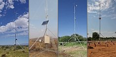
A large number of automatic weather stations has been implemented in the frame of the BIOTA AFRICA project by the Namibian National Botanical Research Institute (NBRI) and the Group "Biodiversity, Evolution and Ecology" (BEE) of the University of Hamburg. The website offers hourly updates of data and graphs of a large number of weather parameters.

|
Subproject E02: GIS and Remote Sensing in Support of Biodiversity Management at the Landscape Scale for Rainforests in Eastern Africa The availability of and capacity to use geo-spatial data are prerequisite to natural resource planning and biodiversity research, this also in the context of climate change. These have been lacking for the Kakamega Forest area and without them distributions and patterns of biodiversity, human use, and forest disturbance cannot be easily discerned. E02 believes that the concept and practice of spatial analysis must be brought into common currency amongst forest managers and researchers as an expected basic ingredient. Thus, the third phase of BIOTA-E02 will see not only the input of BIOTA spatial information into the management and research arena, but also the adoption of measures, facilities, tools and the building of capacity that will allow the continued implementation of spatial aspects into forest and natural resource management planning in Kakamega. Since the spatial analysis of E02 acts as a common platform on which the disciplines of the different subprojects can combine, it is natural that this subproject will be involved in coordinating the BIOTA input into the restarting of the Kakamega participatory forest management process. This will ultimately result in the publication of a revised management plan for Kakamega Forest. To ensure the enduring and sustainable relevance of spatial BIOTA results a GIS-site is to be set up close to the forest for use by ground-level managers of KFS and KWS as well as visiting scientists. E02 will continue its core role within BIOTA-East with an interdisciplinary slant for the analysis of very high to high resolution satellite imagery thus enabling analyses, spatial extrapolation and modelling of biotic, ecological and socio-economic variables. These will inform recommendations for sustainable use of biodiversity in the processes of planning forest management, and of land use planning for the farmland, respectively. This will add to the already impressive body of spatial data generated and collected relating to forest vegetation types, forest cover change, human use and disturbance, and fragmentation patterns. Such data must now be fully integrated and made available necessitating the adoption of a far-reaching information policy seeing the transfer of knowledge to a broad user-group including the forest managers, forest-adjacent community, researchers, conservationists and the public at large. Therefore the objectives for the third phase are:
The regional focus of phase 3 will be Kakamega Forest while the Ugandan counterpart institutions of phase 2 must also be honoured with the presentation and explanation of the E02 data and results.
|
 Go to the WeatherNet
 BIOTA East Africa - Workpackage(s)