 


Weather data
A large number of automatic weather stations has been implemented in the frame of the BIOTA AFRICA project by the Namibian National Botanical Research Institute (NBRI) and the Group "Biodiversity, Evolution and Ecology" (BEE) of the University of Hamburg. The website offers hourly updates of data and graphs of a large number of weather parameters.

|
 BIOTA East Africa - Workpackage(s)
Subproject |
E02 - GIS and Remote Sensing in Support of Biodiversity Management at the Landscape Scale for Rainforests in Eastern Africa |
Workpackage |
WP1: Finalizing the BIOTA-East-GIS (data integration, user interface development, training) and geodata visualization |
Project leader(s) |
Prof. Dr. Gertrud Schaab,
Nick Mitchell,
Nirmal Ojha,
Richard O. Odongo,
N.N. (KWS) |
Project description |
- Integration of additional/up-dated geodatasets for the study areas Kakamega,
Mabira, and Budongo Forests in the BIOTA-East-GIS
- Providing for linking datasets of the BIOTA-East-GIS and BIOTA-East databases
on field data via the georeferencing of the observation plots
- Development of a customized GIS working environment for an effective biodiversity
management by non-geoprofessionals (e.g. biologists, foresters)
- Capacity building mainly of the Kenyan counterparts in the use of the finalized
BIOTA-East-GIS
- Visualizing of BIOTA-East results for environmental education, the decision
makers, and scientists
Workpackage 1 serves as the major contribution in regard to a sustainable use of the BIOTA-derived
geospatial data in the longterm. For finalizing the BIOTA-East-GIS a) the integration of all geo-spatial
data gathered, processed and derived within the 9 years of funding, b) a user interface for geo-spatial
data handling and spatial analyses by non-geoprofessionals, and c) the training of the potential users
in making use of the data and tools provided is envisaged. Furthermore, the workpackage plays a key role
with respect to information policy. A multimedia presentation and many posters serve the purpose of
communicating the work and findings of BIOTA-East to the local people, the decision makers and the
scientific community.
|
Keywords |
GIS, online geodata-catalogue, biodiversity management tool, capacity building, visualisations |
Contribution to
cross-cutting themes (CCT) |
- Monitoring and assessment of biodiversity in space and time (Theme1)
- Capacity building and information policy at local, national,and international levels (Theme5)
|
Link to Subproject |
E01
E03
E04
E10
E11
E13
E14a
E14b
E14c
E15a
E15b
E16
|
|
|
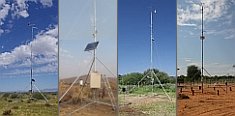
 Go to the WeatherNet