 


Weather data
A large number of automatic weather stations has been implemented in the frame of the BIOTA AFRICA project by the Namibian National Botanical Research Institute (NBRI) and the Group "Biodiversity, Evolution and Ecology" (BEE) of the University of Hamburg. The website offers hourly updates of data and graphs of a large number of weather parameters.

|
 BIOTA East Africa - Workpackage(s)
Subproject |
E02 - GIS and Remote Sensing in Support of Biodiversity Management at the Landscape Scale for Rainforests in Eastern Africa |
Workpackage |
WP3: Identifying structural parameters and modelling socio-economic scenarios for the farmland surrounding Kakamega Forest as well as deriving a detailed up-to-date vegetation map for Kaka-mega Forest as a contribution to forest management |
Project leader(s) |
Prof. Dr. Gertrud Schaab,
Tillmann Lübker |
Project description |
- Analysing yearly photography timeseries (1984-2004, CBS) of agricultural land in regard to major landuse types and structural parameters
- Analysing the QuickBird satellite image data regarding forest corridors and tree patches in the open landscape
- Deriving LU proportions, parcel sizes and fence lengths of the agricultural mosaic from the QuickBird satellite data
- Modelling spatially explicit scenarios of rural livelihood for statements of impact on land use and landscape elements influencing biodiversity (in close cooperation with E14, E11, E10, E04 and E03)
- Producing a Kakamega Forest vegetation map showing plant communities based on the QuickBird imagery (in close cooperation with E04)
Spatially explicit scenarios that bring together socio-economic projections and needs with those farmland landscape elements of importance for
maintaining biodiversity are of high value for landscape planning recommendations. Therefore, in workpackage 3 the 717 km² of QuickBird satellite
imagery covering Kakamega Forest and large parts of the surrounding farmland are analysed in detail. Here, especially the structural parameters
(e.g. forest corridors, parcel sizes, fence lengths) in the agricultural matrix are of interest. Via a farmland typology, scenarios are modelled
incorporating landscape planning recommendations for rural livelihoods capable of protecting biodiversity. For the forested areas a detailed
vegetation map is to be derived.
|
Keywords |
remote sensing, agricultural land surrounding Kakamega Forest, land use and structures, spatially explicit scenarios of rural livelihood, Kakamega Forest vegetation map |
Contribution to
cross-cutting themes (CCT) |
- Monitoring and assessment of biodiversity in space and time (Theme1)
- Understanding natural processes of change (Theme2)
- Understanding human use, value and impact in space and time (Theme3)
- Recommendations and measures for sustainable use of biodiversity (Theme4)
|
Link to Subproject |
E03
E04
E10
E11
E14 E16
|
|
|
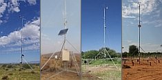
 Go to the WeatherNet