 


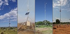
Weather data
A large number of automatic weather stations has been implemented in the frame of the BIOTA AFRICA project by the Namibian National Botanical Research Institute (NBRI) and the Group "Biodiversity, Evolution and Ecology" (BEE) of the University of Hamburg. The website offers hourly updates of data and graphs of a large number of weather parameters.

|
 Ready-to-Use Maps Ready-to-Use Maps
< Geodata ServiceFor download a password is required
| East Africa |
| |
meta information
 |
quicklook
 |
download
 |
| Location Map of KF, BF, MF (bw) |
 |
 |
 |
| Location Map of KF, BF, MF (c) |
|
|
|
| Location Map of KN, BF, MF (bw) |
|
|
|
| Location Map of KN, BF, MF (c) |
|
|
|
| Satellite Image Map |
|
|
|
| Satellite Image Map of KF, BF, MF |
|
|
|
| Satellite Image Map of KN, BF, MF |
|
|
|
| White's Vegetation Map |
|
|
|
| Kenya |
| |
meta information
|
quicklook
|
download
|
| Location Map of KN within Kenya (bw) |
|
|
|
| Location Map of KN within Kenya (c) |
|
|
|
| Kakamega and the Nandi Forests |
| |
meta information
|
quicklook
|
download
|
| Satellite Overview Map |
|
|
|
| Overview Map of National/Nature Reserves |
|
|
|
| Satellite Image Map |
|
|
|
| Land Cover Map Based on Landsat Imagery |
|
|
|
| Land Cover Map (Africover) |
|
|
|
| Map of Land Use/Cover (KIFCON) |
|
|
|
| Map of Natural Vegetation Types |
|
|
|
| Forest Map (1967) |
|
|
|
| Map of Agro-Ecological Zones |
|
|
|
| Terrain Map |
|
|
|
| Terrain Map Including Kenya Location Map (bw) |
|
|
|
| Terrain Map Including Kenya Location Map (c) |
|
|
|
| Map of Elevation Levels |
|
|
|
| Map of Catchment Basins |
|
|
|
| Geology Map |
|
|
|
| Soil Map |
|
|
|
| Map of Administrative Units (1999) |
|
|
|
| Map of Population Density (1999) |
|
|
|
| Kakamega Forest |
| |
meta information
|
quicklook
|
download
|
| Satellite Map with BDO Locations |
|
|
|
| Satellite Overview Map |
|
|
|
| Overview Map of National/Nature Reserves |
|
|
|
| Map of Land Use/Cover (FD) |
|
|
|
| Map of Population Density (1999) |
|
|
|
| Budongo Forest |
| |
meta information
|
quicklook
|
download
|
| Satellite Map with BDO Locations |
|
|
|
| Satellite Overview Map |
|
|
|
| Overview Map of National/Nature Reserves |
|
|
|
| Satellite Image Map |
|
|
|
| Land Cover Map Based on Landsat Imagery |
|
|
|
| Map of Land Use/Cover (NFA) |
|
|
|
| Terrain Map |
|
|
|
| Map of Elevation Levels |
|
|
|
| Map of Catchment Basins |
|
|
|
| Map of Administrative Units (2002) |
|
|
|
| Map of Population Density (2002) |
|
|
|
| Mabira Forest |
| |
meta information
|
quicklook
|
download
|
| Satellite Map with BDO Locations |
|
|
|
| Satellite Overview Map |
|
|
|
| Overview Map of National/Nature Reserves |
|
|
|
| Satellite Image Map |
|
|
|
| Land Cover Map Based on Landsat Imagery |
|
|
|
| Map of Land Use/Cover (NFA) |
|
|
|
| Terrain Map |
|
|
|
| Map of Elevation Levels |
|
|
|
| Map of Catchment Basins |
|
|
|
| Map of Administrative Units (2002) |
|
|
|
| Map of Population Density (2002) |
|
|
|

|
|
 Go to the WeatherNet