 


Weather data
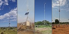
A large number of automatic weather stations has been implemented in the frame of the BIOTA AFRICA project by the Namibian National Botanical Research Institute (NBRI) and the Group "Biodiversity, Evolution and Ecology" (BEE) of the University of Hamburg. The website offers hourly updates of data and graphs of a large number of weather parameters.

|
 WebGIS Applications WebGIS Applications
< Geodata Service
Please use Microsoft Internet Explorer for full
functionality and display of application features.
| Kenya |
| |
application |
created with |
| Orography |
 |
MapViewSVG 2.5 |
| Hydrography |
|
MapViewSVG 2.5 |
| Geology and Soils |
|
MapViewSVG 2.5 |
| Vegetation and Land Use/Cover |
|
MapViewSVG 2.5 |
| Climate |
|
MapViewSVG 2.5 |
| Administrative Boundaries (5 Levels) |
|
MapViewSVG 2.5 |
| Sublocations (6th Level) |
|
ImageMapper 8.3 |
| Infrastructure and Population |
|
MapViewSVG 2.5 |
| Kakamega and the Nandi Forests |
| |
application |
created with |
| Orography |
|
MapViewSVG 2.5 |
| Hydrography and Climate |
|
MapViewSVG 2.5 |
| Vegetation and Soils * |
|
MapViewSVG 2.5 |
| Infrastructure and Administrative Boundaries |
|
MapViewSVG 2.5 |
Flight over Kakamega and
the Nandi Forests |
|
MapViewSVG 2.5 |
3D-View of Northern Part of
Kakamega and the Nandi Forests |
|
MapViewSVG 2.5 |
* names and boundaries of nature reserves not correct
|
|
 Go to the WeatherNet