

Weather data
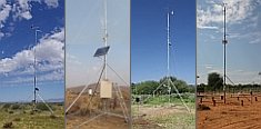
A large number of automatic weather stations has been implemented in the frame of the BIOTA AFRICA project by the Namibian National Botanical Research Institute (NBRI) and the Group "Biodiversity, Evolution and Ecology" (BEE) of the University of Hamburg. The website offers hourly updates of data and graphs of a large number of weather parameters.

|
 BIOTA East Africa - Workpackage(s)
Subproject |
E02 - GIS and Remote Sensing in Support of Biodiversity Management at the Landscape Scale for Rainforests in Eastern Africa |
Workpackage |
WP4: Applying spatial information in participatory forest management and landuse planning for Kakamega Forest and surroundings |
Project leader(s) |
Prof. Dr. Gertrud Schaab,
Nick Mitchell,
Eric T. Nahama |
Project description |
- Restarting a major revision of the Kakamega Forest participatory forest management plan and supporting the process with geospatial
information
- Developing a harmonized monitoring framework (including reporting and subsequent data management) for Kakamega Forest to be used by
the different stakeholders involved in its management
- Setting-up of a geodata-viewing and processing unit in close vicinity to the forest for the use of ground-level management (KFS,
KWS) and research (NMK, any visiting scientist working in Kakamega Forest)
- Close cooperation with the senior wardens/officers and foresters of KWS and KFS to strengthen the likelihood of the GIS-based unit
continuing to run in the long-term as well as of taking full advantage of its potential for forest management
- Providing the landuse planning activities of E14b in the farmland surrounding Kakamega Forest with geospatial information
Workpackage 4 assures that for the management of Kakamega Forest use will be made of the spatial information derived within the BIOTA-East
project. Here, the participatory Kakamega Forest management planning process is restarted and supported in order to get the versatile
BIOTA-East data and findings included in a major revision of the management plan. The setting-up of a GIS-site in close vicinity to the
forest and a close cooperation with the foresters/ managers on the ground will enable the full and continued inclusion of the geodata. As
such, E02 considers a structure of a close cooperation with the main institutions involved in the management of Kakamega Forest to be of
central importance. At the same time these counterparts are asked for contributions which include the GIS-site of use to anybody involved
in management or research and thus contributing to the conservation of the forest. The workpackage also supports the landuse planning
activities in the surrounding farmland with geospatial information.
|
Keywords |
forest management planning, Kakamega Forest, geospatial information, monitoring framework, geodata-viewing and processing unit, cooperation with on-ground management, support of land use planning |
Contribution to
cross-cutting themes (CCT) |
- Understanding human use, value and impact in space and time (Theme3)
- Recommendations and measures for sustainable use of biodiversity (Theme4)
- Capacity building and information policy at local, national,and international levels (Theme5)
|
Link to Subproject |
E01
E02
E03
E04
E13
E14b
|
|
|


 Go to the WeatherNet
 BIOTA East Africa - Workpackage(s)